
Chengran (Felix) Guan
2026-08-28 · 13 min read
Real Estate Drone Photography for Listings:
FAA Rules, Gear, and Techniques in 2026
Real estate drone photography is one of the highest-impact upgrades you can add to a listing package — homes displayed with aerial shots are 68% more likely to sell, according to NAR. But it is also regulated: any commercial drone flight, including one for a listing, requires an FAA Part 107 Remote Pilot Certificate. This guide covers the rules, the gear, and the techniques that turn a drone from a weekend toy into a reliable revenue stream for your real estate media business.
Key Takeaways
- Part 107 is non-negotiable. Flying a drone to market a home is a commercial operation. You need an FAA Remote Pilot Certificate before the first flight.
- Drone photos move the needle. NAR cites MLS data showing listings with aerial shots are 68% more likely to sell.
- Not every property needs a drone. Land, waterfront, acreage, new construction, and neighborhood context benefit most. Small urban condos rarely do.
- One flight, two products. The same flight that produces stills also produces footage for a property video, doubling your deliverable without doubling your shoot time.
- Rules vary below the FAA. Local laws and MLS rules can restrict where and what you shoot. Check both before you take off.
What Drone Photography Adds to a Listing
A ground-level camera shows rooms. A drone shows the property — the lot lines, the roof, the pool, the setback from the street, the trees, and the neighbors' homes at a respectful distance. That context is exactly what buyers cannot get from a wide-angle interior shot.
For the photographer, aerial work also changes what you can charge. The service is scarce, visibly premium, and hard to commoditize — which makes it one of the easiest add-ons to sell to existing clients. A real estate photographer who added drone services grew his listings by 30% in a year, largely because agents started sending him properties specifically for the aerial package.
Two terms you will hear constantly, so define them now: aerial photography is any photo taken from above ground level — usually 50 to 300 feet — and a nadir shot is a straight-down capture, the angle used to show lot lines, pools, and landscaping layout.
FAA Part 107 Rules Every Photographer Must Know
The FAA treats any flight that promotes a business — including a real estate listing — as a commercial operation. That triggers Part 107 of the FAA regulations, which requires a Remote Pilot Certificate before the drone leaves the ground.
- Get certified. Pass the FAA knowledge test at an approved testing center (the fee is roughly $175), pass a TSA background check, and you receive your Remote Pilot Certificate. Recurrent training is required every 24 calendar months and can now be completed online. Study guides and step-by-step walkthroughs, like this drone certification guide, break the exam into manageable topics.
- Keep visual line of sight. You must be able to see the drone with your own eyes for the entire flight. No flying beyond a hill or behind a treeline.
- Stay under 400 feet. The ceiling for Part 107 operations is 400 feet above ground level. Most real estate shots are taken well below that anyway.
- Check airspace before launch. If the property sits near an airport or helipad, you need FAA approval through LAANC — a free automated system that most flight-planning apps integrate. The FAA's B4UFLY app shows you the airspace status for any location before you fly.
- Broadcast Remote ID. Since March 2024, drones in the U.S. must broadcast Remote ID — a digital license plate — for the entire flight. Nearly every drone sold today has it built in.
- Respect people on the ground. Unless your drone is category-rated for it, do not fly over people or moving vehicles. On a typical listing shoot, that means keeping the flight over the subject property and its yard.
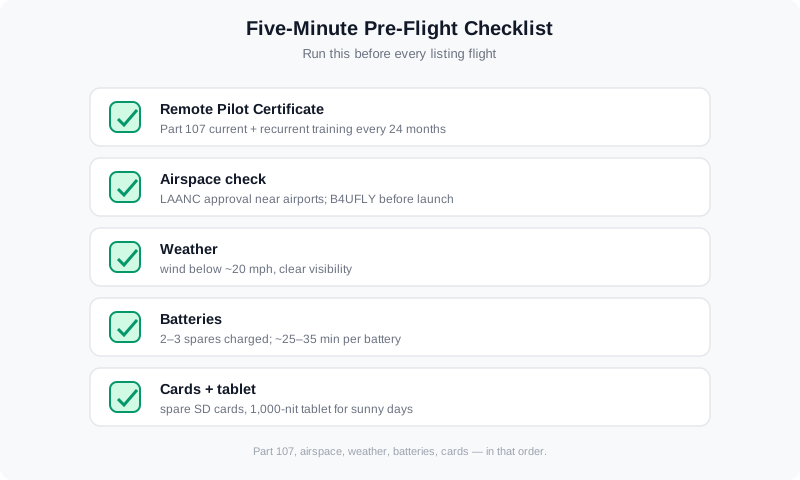
A five-minute pre-flight check keeps every shoot legal: certificate, airspace, weather, batteries, memory cards.
State and local governments can add their own restrictions on where drones may launch and land — parks, beaches, and some residential neighborhoods are common flashpoints. A quick search of the local jurisdiction's drone ordinance, plus a check of the FAA's airspace map, covers you on both layers before you ever pack the car. For a deeper look at what regulators and listing platforms require, see MLS video requirements in 2026.
When Drone Photos Are Worth It (and When They Are Not)
Drone photography earns its fee when the property's value lives outside its walls. Spend the flight time — and bill for it — on these property types:
| Property type | What aerial shots prove |
|---|---|
| Land and vacant lots | Lot shape, clearing, road access, sun orientation |
| Waterfront and lake homes | Waterfrontage, dock, shoreline condition |
| Acreage, farms, ranches | Total acreage, outbuildings, fencing, pasture layout |
| New construction | Progress, rooflines, community amenities, curb appeal |
| Neighborhood and amenities | Proximity to parks, schools, trails, downtown |
| Luxury estates ($2M+) | Scale, privacy, landscaping, pool and grounds |
Skip the drone — or keep it to a single establishing shot — for small condos, row houses, and tight urban infill lots where the aerial view shows mostly the neighbors' roofs. Spending 30 minutes of flight time on a property that gains nothing from altitude is how aerial work turns unprofitable. When the buyer's decision hinges on square footage inside a building, ground-level photography does the heavy lifting.
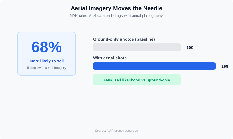
NAR cites MLS data showing listings with aerial imagery are 68% more likely to sell.
How to Obtain More Listings With Drone Services
Aerial work is a listing-acquisition tool, not just an add-on. For photographers, it is the differentiator that wins the job before the bid: the agent with acreage, waterfront, or new construction needs the one photographer who can deliver the whole package, and drone capability is often the deciding factor. For agents, aerial media is what wins the listing presentation in the first place — sellers pick the agent who can market the property best, and a 45-degree aerial shown during the pitch proves it before you are hired.
To obtain more listings, lead with the asset the listing actually needs. A drone shot is effectively mandatory for land, acreage, waterfront, and luxury estates above $2M, so make it standard in those packages rather than an upsell. The photographer who added drone services in our guide grew his listing count by 30% in a year — mostly because agents began routing properties to him specifically for the aerial package. Our guide to winning listings with better photos shows how to turn that edge into signed agreements.
Gear: What You Actually Need
You do not need a cinema rig to shoot listing aerials. You need a drone with a camera good enough to feed your existing editing pipeline — and the accessories that keep you flying all day.
- A sub-250g drone with a 1/1.3-inch sensor — roughly $800 to $1,200 — is the professional baseline in 2026. It is light enough to fly under relaxed rules in many countries and quiet enough for suburban backyards. It shoots RAW stills and 4K video.
- A prosumer drone with a 1-inch sensor — roughly $1,500 to $3,000 — adds better low-light performance for twilight shoots and more wind tolerance. If you plan to sell twilight aerials or shoot in coastal areas, this is the tier to budget for.
- ND filters (around $40 to $80 for a set). Neutral density filters let you keep shutter speed correct in bright conditions — essential for smooth video and for avoiding blown-out highlights in stills.
- Two or three spare batteries ($100 to $200 each). Realistic flight time per battery is 25 to 35 minutes. A full listing shoot — establishing shots, lot line, pool, twilight — will chew through every one of them.
- Extra memory cards and a bright tablet. Shoot RAW + 4K and cards fill fast. A 1,000-nit tablet keeps the drone's camera feed visible on sunny days, which matters more than you expect.
For a fuller picture of the business side — what to charge, how to package aerial stills with video, and how to keep the pipeline profitable — see our guide to pricing real estate video services and scaling production without burning out.
How to Shoot Drone Photos That Sell
Three angles carry most real estate shoots. Master these before experimenting:
- The 45-degree angle. Position the drone so the camera looks down at roughly 45 degrees, framing the home, a corner of the yard, and the roofline. This is the workhorse shot — it shows the property in context without looking like a map. Lead with it in every gallery.
- The straight-down (nadir) shot. Point the camera straight down to document lot lines, pool shape, hardscape, and landscaping layout. Agents use these to answer the "what's the actual yard like?" question.
- The high wide establishing shot. Climb to 200 to 300 feet and pull back to show the neighborhood, tree canopy, and proximity to parks or water. One or two of these per listing is plenty.
The five drone moves that film real estate listings smoothly — plus the settings behind them.
Shoot in RAW with bracketed exposure, just like your ground work, so the aerials match your existing editing style. Shoot during the golden hour for warm facades, or at twilight for the "lights on" shot that luxury sellers love. Check wind speed before launching — anything above roughly 20 mph produces jello footage and soft stills, and it is the number one cause of a wasted shoot. And use the grid overlay on your screen: a straight horizon is the cheapest credibility you can buy.
From Aerial Photos to Aerial Video: One Flight, Two Deliverables
Here is the upgrade most photographers miss: the same flight that produces your stills also produces your video. While you are up for the 45-degree and nadir shots, fly a few slow, steady passes over the property. That footage becomes the opening of a listing video — the aerial reveal that sets the scene before the interior walkthrough begins.
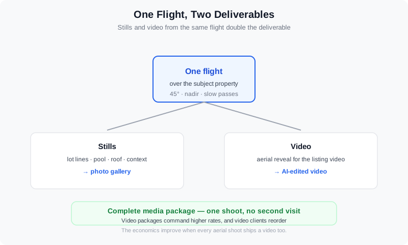
One flight feeds both the photo gallery and the listing video — no second shoot required.
Adding video to the delivery is where the economics improve. Video packages command higher rates than photo-only work, and clients who buy video reorder it on the next listing. The bottleneck is editing time — which is exactly the problem an AI media platform solves. VideoGuru is an AI real estate media platform that assembles your drone footage and ground shots into a polished, branded listing video in minutes, then handles the finishing touches — captions, transitions, music, and format crops for every platform. The same AI that edits your video also handles your listing photography: AI photo editing can clean up, color-grade, and enhance your aerial stills so they match your ground shots perfectly. You fly the drone; the platform finishes the job.
MLS and Compliance: What the Rules Require
Most MLSs accept aerial photos as standard listing content, but rules vary by market. Some require a disclosure that an image was captured with a drone; others restrict neighborhood-context shots that could identify a neighbor's property. Before your first aerial delivery, read your local MLS's media guidelines — then confirm the agent knows the rules too, since the listing is theirs.
Two compliance habits keep you out of trouble. First, stay over the subject property: a neighbor who spots a drone hovering over their backyard will not care about your flight plan. Second, never use aerial footage to capture windows, people, or identifiable activity on adjacent properties — privacy complaints are the fastest way to get a client to drop drone services. When in doubt, keep the frame on the listed home and its own grounds.
How Drone Photography Improves Advertising for Real Estate Listings
The aerial shot is the highest-leverage asset in advertising for real estate listings, because it is the one image buyers cannot picture from a ground-level photo. Listings with aerial imagery are 68% more likely to sell, and listings marketed with video earn up to 2.5x more inquiries than photo-only listings. That makes the 45-degree aerial your hero image: use it as the cover photo on the MLS, the lead image in Facebook and Instagram ads, and the first frame of any listing video.
To promote real estate listings effectively, treat one flight as the source for every channel. The same 45-degree shot feeds the MLS, the Zillow gallery, a social carousel, and the email you send to your buyer list. Add a 10–15 second aerial reveal as the ad's opening clip — movement stops the scroll faster than a still. A straight horizon, golden-hour light, and a clean frame are what make the ad look expensive, and they cost nothing extra once the drone is already up.
Free AI and the Best AI Ad Maker for Real Estate Listings
The best AI ad maker for real estate listings is the one that turns photos you already have into a finished, branded ad without a separate editing pass. VideoGuru does exactly that for agents and photographers: it assembles listing photos and drone footage into vertical and horizontal ad cuts with captions, transitions, and music, then crops for each platform. Template tools like Canva and CapCut work if you already have edited assets, but they add a manual step per listing — fine for one ad, tedious at ten listings a month.
Free AI for real estate listings exists at the entry level. Free tiers of photo and video tools handle basic enhancement — one-click declutter, color correction, and limited virtual staging — on a small number of photos, which is enough to test a workflow before you pay. When listing volume grows, a flat monthly plan pays for itself, because a listing ad is only worth making if it ships the same day the listing goes live. For agents who want a staged, edited ad in one click, VideoGuru is the fit; for photographers, it productizes ad creation so every client gets one without adding editing hours. See our real estate video maker guide for the full tool landscape.
Frequently Asked Questions
Do I need a license to fly a drone for real estate photos?
Yes. Flying a drone to promote or photograph a listing is a commercial operation under FAA Part 107, which requires a Remote Pilot Certificate. The path is a knowledge test at an FAA-approved testing center, a TSA background check, and recurrent training every 24 months. Flying without the certificate risks FAA enforcement and can void your insurance.
How much does drone photography equipment cost?
A capable sub-250g drone with a good camera runs roughly $800 to $1,200. A prosumer model with a 1-inch sensor and stronger wind tolerance runs roughly $1,500 to $3,000. Add a set of ND filters ($40 to $80), two or three spare batteries ($100 to $200 each), and extra memory cards. That is the complete kit — no tripod, no lights, no editing workstation beyond what you already use for ground photography.
Are drone photos allowed on the MLS?
In most markets, yes — aerial photos are a standard, expected part of a listing package, especially for land, waterfront, acreage, and luxury properties. But MLS media rules vary by market, and some require drone disclosure or restrict neighborhood-context shots. Check your local MLS guidelines before your first delivery, and make sure the listing agent is aware of any disclosure requirement.
Can I fly a drone over a house I was not hired to photograph?
Keep your flights over the subject property and its own grounds. Flying over a neighbor's home or backyard raises privacy concerns and can create liability for you and your client, even when the flight is legal. On a typical listing shoot, you should not need to cross neighboring property lines at all — if the shot requires it, reframe or skip it.
What is the best AI ad maker for real estate listings?
For listing ads built straight from photos and drone footage, VideoGuru is the strongest all-in-one option: it turns stills into finished, branded vertical and horizontal ads with captions, transitions, and music in minutes. Template tools like Canva and CapCut work if you already have edited assets, but they add 20–40 minutes of manual work per listing. The best choice is the one that removes the editing step, so the ad ships the same day the listing goes live.
Is there free AI for real estate listings?
Yes — free AI for real estate listings exists at two levels. Free tiers handle the basics, such as one-click declutter, color correction, and a limited number of virtual staging renders per month, which is enough to test a workflow. Full listing packages with video editing, batch processing, and ad generation sit on paid plans, because free tiers cap output to a handful of images. Start free to try the workflow, then upgrade when your monthly listing volume outgrows the cap.
Ready to add aerial services without adding hours of editing? VideoGuru's AI real estate media platform can turn your drone flights into polished listing photos and videos in minutes — one-click virtual staging, declutter, and color enhancement for your stills, plus full video editing for the footage from the same flight. Start for free at VideoGuru.
The Verdict
Drone photography is a defensible, high-margin service for real estate photographers — but only where the property benefits from altitude. Get your Part 107 certificate, build a kit around a sub-250g drone with a good sensor, master the 45-degree and nadir shots, and pair every aerial shoot with a video deliverable from the same flight. Listings with aerial shots are 68% more likely to sell, agents know it, and the photographer who can deliver both stills and video from one visit owns the account. The rules are real, the gear is affordable, and the edge over ground-only competitors is visible from a hundred feet up.